NewTopo - Tongariro Alpine Crossing Topo Map
Walk one of New Zealand's most iconic alpine crossings.
![]()
Overview
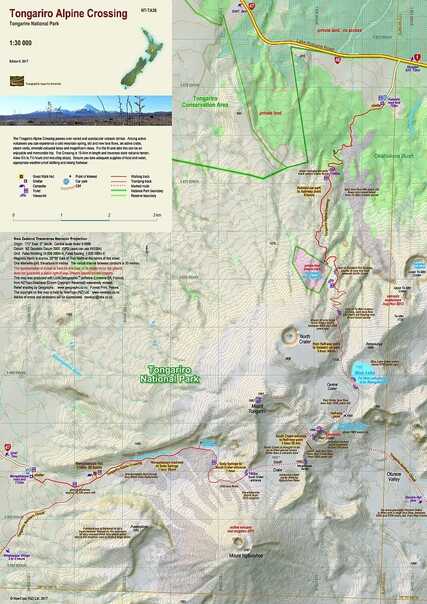
More than 126,000 people walk the Tongariro Alpine Crossing in Tongariro National Park each year. This map shows the route and its unique geographic environment at a scale where all features can be identified, increasing both the enjoyment and safety of walkers.
The combination of the large scale, twenty-metre contours and relief shading, gives a realistic landform. Geological notes on the volcanoes add an educational aspect to the journey.
Edition 7, 2020. Scale 1:30 000
Technical Specs
- Small format 297x420mm
- Folded to 120x200mm
- 20m contours
- 1km grid
- 10 minute geographic graticule
- New Zealand Transverse Mercator projection
- Printed on 85gsm Yupo waterproof synthetic paper
Original: $8.08
-70%$8.08
$2.42Product Information
Product Information
Shipping & Returns
Shipping & Returns
Description
Walk one of New Zealand's most iconic alpine crossings.
![]()
Overview
More than 126,000 people walk the Tongariro Alpine Crossing in Tongariro National Park each year. This map shows the route and its unique geographic environment at a scale where all features can be identified, increasing both the enjoyment and safety of walkers.
The combination of the large scale, twenty-metre contours and relief shading, gives a realistic landform. Geological notes on the volcanoes add an educational aspect to the journey.
Edition 7, 2020. Scale 1:30 000
Technical Specs
- Small format 297x420mm
- Folded to 120x200mm
- 20m contours
- 1km grid
- 10 minute geographic graticule
- New Zealand Transverse Mercator projection
- Printed on 85gsm Yupo waterproof synthetic paper