NewTopo - Aoraki Mt Cook Topo Map
Explore the iconic Mount Cook area with this NewTopo map.
![]()
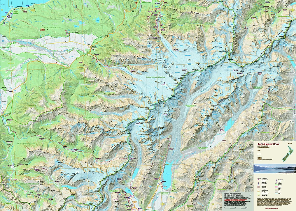
Overview
The iconic Mount Cook area is the highest part of the Southern Alps. The map covers all the major features including the Copeland Valley and Pass, and the Fox and Franz Josef Glaciers west of the Main Divide.
The map shows large parts of the Mount Cook and Westland National Parks. This new edition shows the National Park boundaries as well as the boundaries of other reserves.
Edition 2 2018. Scale 1:65 000
Technical Specs
- Large format 840x600mm
- Folded to 120x200mm
- 20m contours
- 1km grid
- 10 minute geographic graticule
- New Zealand Transverse Mercator projection
- Printed on 90gsm Polyart waterproof synthetic paper
Product Information
Product Information
Shipping & Returns
Shipping & Returns
Description
Explore the iconic Mount Cook area with this NewTopo map.
![]()
Overview
The iconic Mount Cook area is the highest part of the Southern Alps. The map covers all the major features including the Copeland Valley and Pass, and the Fox and Franz Josef Glaciers west of the Main Divide.
The map shows large parts of the Mount Cook and Westland National Parks. This new edition shows the National Park boundaries as well as the boundaries of other reserves.
Edition 2 2018. Scale 1:65 000
Technical Specs
- Large format 840x600mm
- Folded to 120x200mm
- 20m contours
- 1km grid
- 10 minute geographic graticule
- New Zealand Transverse Mercator projection
- Printed on 90gsm Polyart waterproof synthetic paper